


The Nihon Invasion of San Francisco
A Scenario for Deluxe G.E.V.
by Keith Johnson
Aerial Photography produced by the U.S. Geological Survey
History
2099: Overextended Combine withdraws entirely from South America, abandoning Amazon Combat Zone.
2100: "Crash of 2100." More rebellions in Europe. In North America, Quebec and Northern California rebel. All Combine troops called home. Some units stationed in Europe refuse, either making common cause with local governments or remaining as independent military overlords.
2101: Combine collapses into dozens of local governments. Revolutions spread in Europe. Nihon "peacekeeping" forces dispatched to Hawaii, California, Seattle, Santiago and other Combine West Coast cities.
In 2101, Nihon dispatches military forces to seize control of the Pacific coast from the balkanized ruins of the Combine. One of the primary targets in California was the San Francisco Bay Area. Armed with surveillance data and a taskforce consisting of a G.E.V.s, marine infantry, a Naval Frigate and an Ogre Mk. V, Nihon military intelligence experts predicted the quick collapse of San Franciscan defenses.
Unfortunately, their surveillance data was wrong.
San Francisco was the final destination of a large number Combine troops that had been withdrawn from South America. Along with the military of the fledgling state of Northern California, San Francisco has an invaluable combat veteran from the Amazon Combat Zone, a self-aware Ogre Mk. III. While the Northern Californian Defense Forces are initially disorganized, under the Nihon assault their combat training kicks into high gear.
In the end, Nihon must pay for every kilometer of territory they seize, but with San Francisco the rest of Northern California will quickly fall . . .
Map

The San Francisco battle map to the right is a small version of the full map, which is set to Deluxe Ogre map size. For an Ogre/G.E.V. sized map, see below.
This map makes use of terrain as specified in Ogre/G.E.V.. If you are using Deluxe Ogre exclusively, then you can ignore the terrain effects, but you will miss out on what infantry really become in an urban environment.
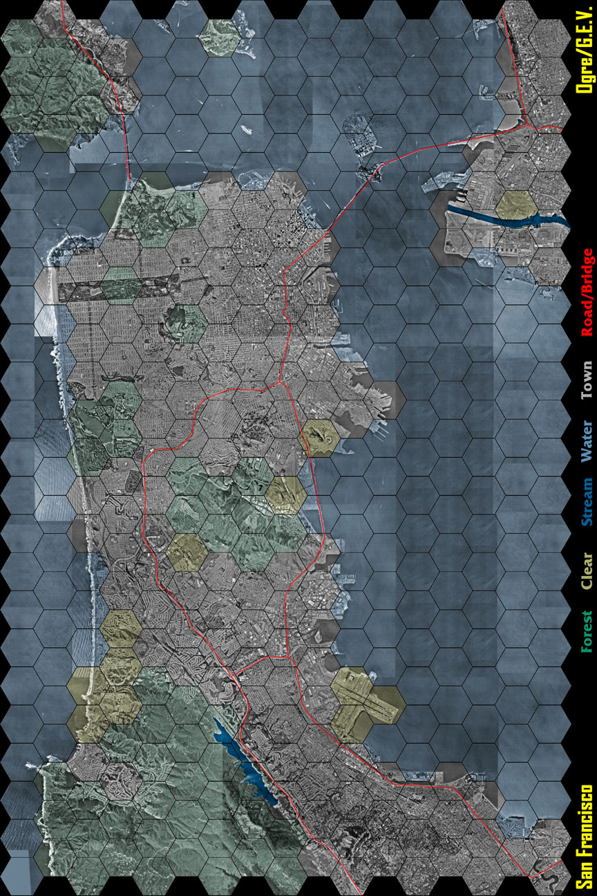
The blue hexes are water, the dark blue areas are streams, the red lines are roads, the yellowish hexes are clear terrain, the green hexes are forests and the greyish white hexes are town. In case you haven't noticed, this map is all about urban conflict.
The entire map is 24" wide by 36" high. Each hex is 1½" wide, and represents a width of 1.5 kilometers. All of these files at 72 dpi JPGs and the picture is a composite of Color Infra-Red (CIR) digital orthophoto quadrangles that were photographed on by the National Aerial Photography Program in 1995. The aerial photographs are accurately scaled as to match Deluxe Ogre hex widths.
- Entire full size map [1.3Meg]
- Full size north west quarter of map (includes Marin, Golden Gate Bridge and most of San Francisco) [375K]
- Full size north east quarter of map (includes Market Street, Bay Bridge Bridge, Treasure Island, Oakland and Berkeley) [276K]
- Full size south west quarter of map (includes Pacifica and most of the entire San Francisco peninsula) [392K]
- Full size south east quarter of map (includes San Bruno, San Mateo and San Francisco Internation Airport) [283K]
- Half sized Ogre/G.E.V. map [360K]
Map Landmarks
North West Quadrant
The upper left corner of the board is Marin County. From here, the Golden Gate bridge stretches down and into San Francisco. Accessing the Golden Gate can either take place in two forest hexes in San Francisco (the Presido) or from the town hex in Marin (Sausalito). Water vehicles can move under the Golden Gate without any problems, and they cannot use the bridge without going to the previously mentioned hexes. The bridge is not reinforced, and can be destroyed as per standard G.E.V. rules.
My house is around three hexes northwest from the northernmost road hex.
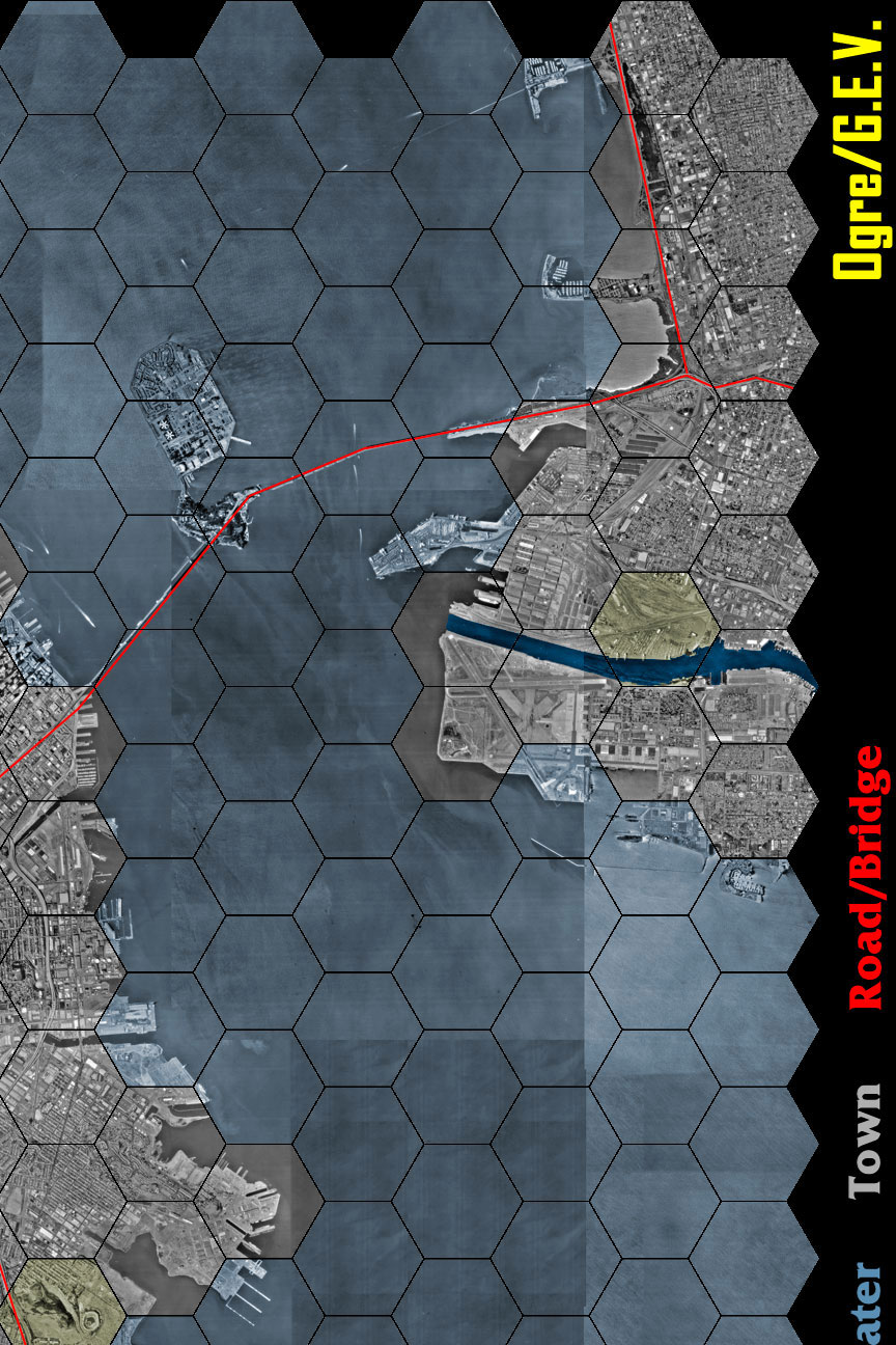
North East Quadrant
The upper left corner of the board covers part of the San Francisco Bay, Oakland, Berkeley, the Bay Bridge and Treasure Island. For the sake of the game, Treasure Island is considered water terrain. All units consider it as they do the rest of the Bay. The Bay Bridge itself is only accessible by the two town squares on either side of it, one in San Francisco (near the heart of Market Street) and one in the East Bay (near the highway 80/580 interchange). The bridge is not reinforced, and can be destroyed as per standard G.E.V. rules. Don't forget to note the stream near the Oakland docks.
South West Quadrant
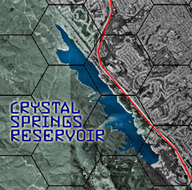
Crystal Springs Reservoir is the only notable area in this quadrant. Consider each hex containing the Reservoir to be a stream.
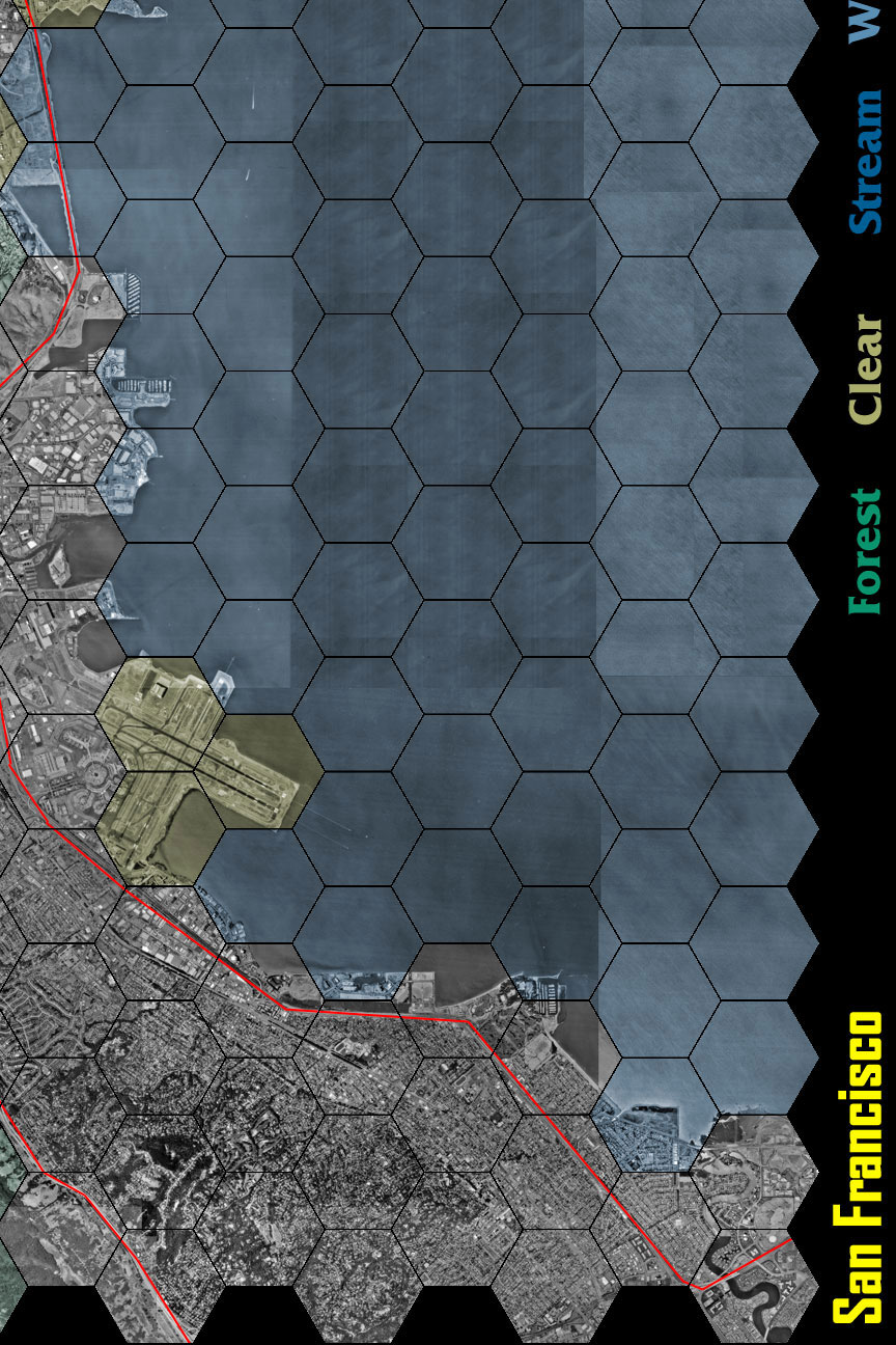
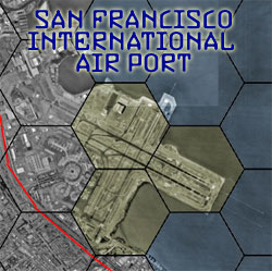
South East Quadrant
Beyond the large amount of water hexes, the San Francisco International Airport is the most notable landmark in this quadrant.
Scenario: The Nihon Invasion of San Francisco

My final 24" × 36" version was printed on a large scale printer at Kinko's, on semi-gloss paper to use for Deluxe Ogre.
Combine Forces
Starting position: Combine forces can begin anywhere on the board. Of the three command posts, one must start in the East Bay (around Oakland/Bekeley), another in San Francisco Airport, and the third must be located on the San Francisco peninsula, in either the North East or North West quadrant.
Ogre Mk. III: "Willie" is a standard Mk. III.
2 Naval Gunboats: These naval ships are completely automated, and has the firepower of a typical Ogre Mk. I. It is identical to a Mk. I, except for the following modifications: It is only able to move on Water hexes, is destroyed after losing all of it's Hull units (it sinks), increased fire control allows an increased range for it's weaponry (+1 hex), and no anti-personel weapons.
1 Main Naval Battery: 4/4 D4:    O
MP 3 : 15 Hull Units:
O O O	O O   (2 MP)
O O O	O O   (1 MP)
O O O	O O   (0 MP)
Twenty Infantry Units
Seventeen Armor Units
Three Command Posts: Note starting position above.
Nihon Forces
Starting position: Nihon forces start from the left side of the board (west, towards the ocean). All non-aquatic units (ie, all units except Ogres, marine infantry, navy ships, G.E.V.s or units carried G.E.V.-PCs) must start on land, and in Marin.
Ogre Mk. V: "Dogen" is a standard Mk. V.
Naval Frigate: This naval ship is heavily automated, and has the firepower of a typical Ogre Mk. II. It is identical to a Mk. II, except for the following modifications: It is only able to move on Water hexes, is destroyed after losing all of it's Hull units (it sinks), increased fire control allows an increased range for it's weaponry (+1 hex), and no anti-personnel weapons.
1 Main Naval Battery: 4/4 D4:    O
2 Secondary Naval Batteries: 3/3 D3:    O O
MP 3 : 30 Hull Units:
O O O O O  	O O O	O O   (2 MP)
O O O	O O  	O O O	O O   (1 MP)
O O O	O O  	O O O	O O   (0 MP)
Twenty Infantry Units: Marines costs double, but can start in water terrain.
Ten Armor Units: Non-aquatic armor units must start in Marin.
Victory Conditions
- The destruction of the three Combine command posts and the retreat or destruction of all Combine military units is a major victory for Nihon.
- The destruction of the three Combine command posts despite the destruction or retreat of all Nihon units is a pyrrhic victory for both sides.
- The retreat or destruction of the Nihon invasion force while keeping at least one command post is a major victory for the Combine.
Random Thoughts
Modifying the Scenario
Adding Combine Laser Towers and off map Nihon Cruise missiles (launched from a Pacific task force) should spice up the scenario.
Martin Halbert's BPC Subs article also has some food for thought. SEVs (LSEV & SES), submarines, and laying mines are all options to help maximize the carnage you find in water terrain. Mine the Bay, and let the GEV's sort it out.
If you have any suggestions to improve the scenario, or if you have developed another scenario using the same map, please drop me an email at [email protected]. I would love to know how other people are using it!
Map Bashing
I have gotten a few emails on just how I made the map. Honestly, it's nothing more than a cut and paste job with my trusty browser and Photoshop.
The USGS photographs were taken from screen captures of Microsoft's TerraServer website (www.terraserver.com). I simply zoomed down till I got the map to the right scale as the Deluxe Ogre/G.E.V. maps (1½" = 1500 meters), and then scrolled about and imported the pictures as different layers in Photoshop. It's pretty easy to line up different layers in Photoshop so the pictures overlapped and lined up perfectly. A professional print quality resolution isn't needed, so screen captures did the job. I could have bought the actual photographs and scanned them for a better resolution, but at around $45 per finished battlemap, I think I've spent enough money. Time to start painting minis!
I grabbed an EPS hex map that was on the SJ Games site (there are tons of them on the net), and scaled it for the proper size. That became the top layer for the map. All the hexes on the side of the map got filled with with solid black to highlight exactly where the board starts and stops.
After all that was taken care of, it was just a matter of deciding what terrain went with each hex. My rule of thumb was that if water took up fifty percent or more of the hex, it became a water hex. As there is no Mountain terrain in G.E.V., I simply assigned the mountainous area of South San Francisco as Forest. I did the same for most of Marin (which is the Bay Area's version of "A Green And Pleasant Land") and whatever hex appeared to have Forests. Mainly, Pacifica and the southwest bay. Any hex that looked like it didn't have massive sprawl, industrialization or forests (which is very rare on the peninsula), got marked with the clear terrain. The only two areas that looked like a decent candidate for streams were the Crystal Springs Reservoir and the water inlet going into Oakland and Alameda. All the other hexes were urban sprawl, and were given the quaint sounding terrain name of Town. Each terrain got a color (and a layer in Photoshop) and with a couple clicks of the mouse, the map was colorized.
As for the roads, I just followed highway 80 through Berkeley, across the Bay Bridge and the split into highway 280 & 101. The two are connected further south with highway 380. 101 is marked down from Marin, and across the Golden Gate. Technically, 101 goes east along Lombard Street and then south down Van Ness until it becomes a real highway again. As far as I am concerned, 101 joins the rest of San Francisco sprawl, so the highway simply terminates once it crosses the end of the Golden Gate Bridge.
That is pretty much it. At worst, it was a 132 meg Photoshop file, despite being only 72 dpi! Luckily, it dropped to 15 megs when I flattened the image and took it to Kinko's on a zip disk. Kinko's had a special on 24" × 36" printouts, so I cropped an entire line of hexes on the East. Unfortunately, Alameda was wiped out and the East Bay Area became more vulnerable to water based attacks. Kinko's normally charges by the square foot (like twelve bucks or something obscene), so I went with the special.
My copy is printed on semi-gloss paper, and looks pretty good. Time will tell how resistant it is to wear and tear, and constant use of minis. I'm betting it will do just fine.
Special Thanks: My daughter, Danica. The entire map was created during the delirium that being a new father creates. The total lack of sleep helped inspire me to actually stick with this project. Many hours of rocking back and forth, singing silly nursery rhymes (including reading the G.E.V. rules aloud and in a singsong voice), and clicking things with my mouse pretty much sums up the creation of this map. Hopefully, I'll find a better way to keep my creative juices going in the future.
